1000+1 CAVES at “LEFKA ORI” MASSIF, ON CRETE, GREECE
Ανεβάζω εδώ την εργασία για τα σπήλαια στα Λευκά Όρη όπως παρουσιάστηκε στο Διεθνές Συνέδριο της UIS στο Brno της Τσεχίας το 2013. Αφορμή για την ανάρτηση είναι η πρόσφατη παρουσίαση στο κανάλι του ΠΡΩΤΕΑ στο facebook - μέσω streaming όπως έλαβε χώρα την Τρίτη του Πάσχα (21/4/2020)
Μπορείτε να δείτε το βίντεο από την παρουσίαση στο κανάλι του Πρωτέα στο youtube
To paper μπορείτε να το κατεβασετε από εδώ
Ακολουθεί η αγγλική περίληψη:
Μπορείτε να δείτε το βίντεο από την παρουσίαση στο κανάλι του Πρωτέα στο youtube
To paper μπορείτε να το κατεβασετε από εδώ
Ακολουθεί η αγγλική περίληψη:
Crete, the
fifth largest island in the Mediterranean sea has been subject to numerous
speleological, archaeological and geological expeditions over the years. Nearly
50% of the island is covered by
limestones in the form of high rocky mountains.
Lefka Ori massif is located to the west side, in Hania district and it is
the second highest on Crete (Pahnes, 2454m) and the largest by surface. The
massif has a unique shape which is formulated by its 54 peaks - counting only
those higher than 2000m altitude) and holds some of the deepest caves in Greece
including the deepest and the second deepest (both deeper than -1000m). Expedition reports from local or international
teams targeting this amazing mountain are dating back in the early seventies
and have revealed some unique caves and big shafts e.g. the well know Mavro
Skiadi (shaft, -342m), Drakolaki cave (+175m), (Katavothra tou) Tzani (-280m),
Gorgothakas (-1208m), Lion cave (-1110m) and others. The majority of these
reports - especially those published before the year 2003- are having limited
information on the exact geographical location of the caves explored and/or
located. With the world "exact" the author means coordinates of
entrance recorded with a GPS (Global Positioning System) device which can be then
re-used by other GPS or GIS (Geographic Information Systems) software. This fact
(lack of entrance coordinates) influenced
a new era of speleological projects in the area initiated by SELAS
speleological club of Athens (in 2003) and a number of local and foreign
contributors (clubs or individuals).
Thanks to excellent cooperation developed between local and international teams (the
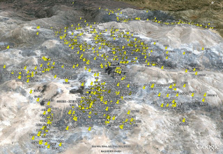
contributors), 1119 cave entrance
coordinates have been recorded and consolidated in one single database. The
effort lasted 9 years so far and the author apart from taking part in many of
the above field trips, has been also the person collecting and consolidating
the datasets from the teams involved. If we take into account the known work of
other teams that concern datasets which are due to be shared with the author, the
number of validated cave entrances in the massif are (today) more than 1400. The geocoded
information provides new perspectives and opportunities in better understanding
and exploiting speleological GIS datasets of the Lefka Ori massif. The subject
of this paper is mainly presenting this dataset, the contributors and the
effort and method used and makes a first attempt in exploiting this dataset.
Announcing the outcome of this project to the global speleological community is
also interesting as a benchmark and to share best (or worst) practices with
other similar works carried out around the world.


